By Jack Brittle, Local Journalism Initiative Reporter
On February 19, the City of Burlington held a community engagement session about the ongoing Ward Boundary Review that the city is undertaking.
The session was online and facilitated via Zoom. Residents could obtain a link to the session on the Get Involved Burlington website.
Robert Williams and Zac Spicer, independent public affairs consultants working on the project for the city, hosted the session.
The city is currently in phase two of the review process.
Spicer presented the seven preliminary options that residents can provide input on, while Williams provided extra context and clarity on the process.
After the presentation, both consultants fielded questions from participants that could be submitted via a Q&A box in the Zoom meeting.
Williams started off the meeting by providing context to the process, explaining the way wards and council are currently set up and outlining the few guidelines the province has legislated that municipalities must adhere to.
Williams also explained that council directed the independent consultants, as well as Watson & Associates, the other consultants involved in the review, to rule out any option that increased the number of current wards (there are six).
This was done because councillors decided that the current structure of every ward councillor also serving as a regional councillor should be maintained. Since the number of regional councillors is capped at six by Halton Region, six is the maximum number of wards under consideration.
Spicer spoke about the ways in which the current ward division is meeting the needs of residents.
“The current ward system is doing a couple of very good things,” Spicer said. “The first one is it is largely keeping communities of interest intact. Where we see some challenges is around population parity. Three of the wards are outside the 15% optimal range.”
The optimal range is calculated by taking the average population and dividing it by the number of wards.
Wards 3, 4 and 6 are outside of the optimal range, with the largest discrepancy representing about 13,000 people. Population projections for 2035 also see these gaps widen, with the largest gap growing to 21,000 people.
“We know that there is growth coming in Burlington, but this is not going to be evenly distributed,” Spicer said.
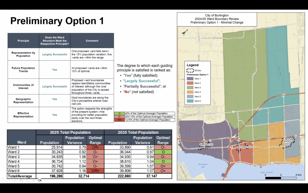
The first option discussed presented similar boundaries to that of the current map but with a few notable changes.
“The biggest change is in the area between Upper Middle Road and the lakes, where Ward 4 stretches directly along the lake, there is some transfer between Ward 3 and 4,” Spicer said. “We had heard from some of the residents in Maple that they feel more aligned with Ward 2 and the downtown Burlington community.”
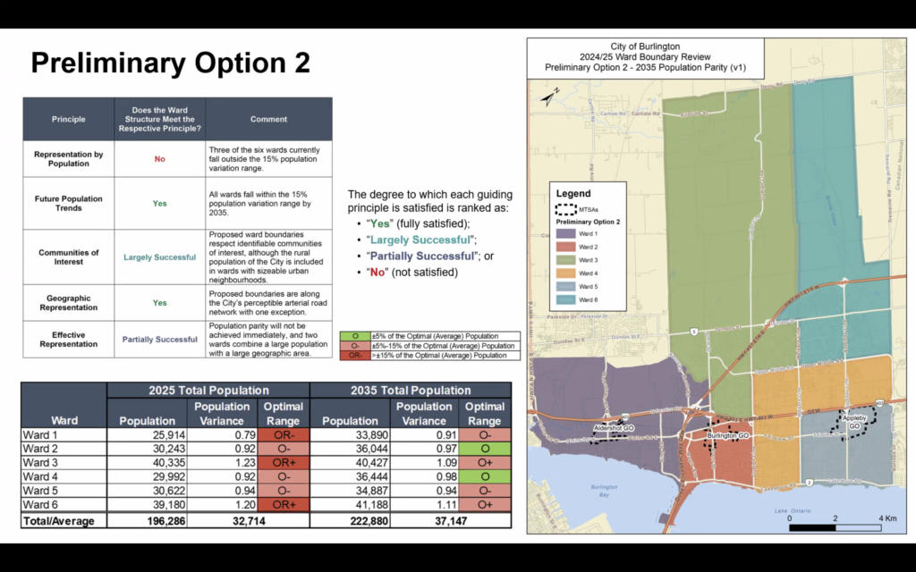
Option two would create better population parity in 2035, but worsen some of the numbers in the short term.
Spicer spoke about the potential options surrounding the more rural areas of the city.
“There are still those two northern wards, I wanted to draw your attention to that,” Spicer said. “Because in some of the other options, we have tested out designs where there is one rural northern ward. Right now there are three wards that could be considered rural in nature.”
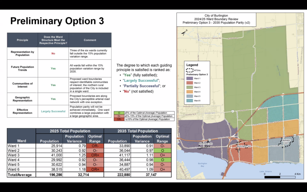
Option three presents one northern ward.
“One of the rationales…is this is just the representation needs of those who are living in the northern, rural part of Burlington,” Spicer said. “Is it better to have one councillor for the entire area or potentially two? That is something that we are seeking feedback on as we present these options.”
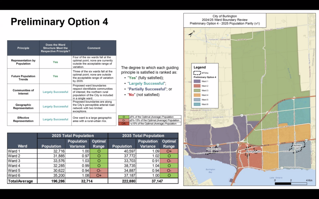
Option four also has one large northern ward and features good population parity in both the short and long term.
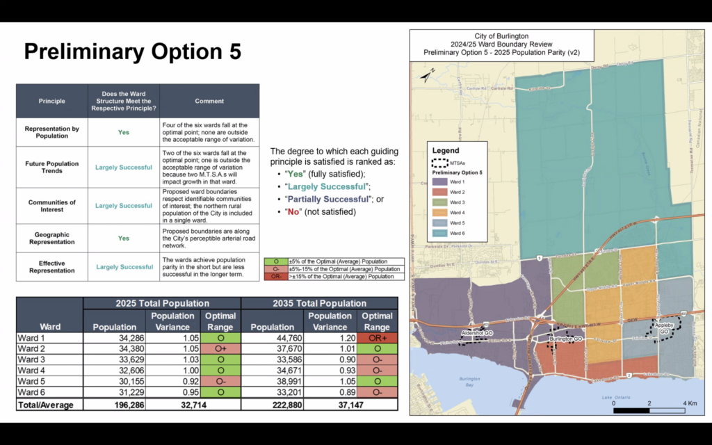
The fifth option also has good population parity, but is a more “sizable change” than the other choices, according to Spicer.
“It is a bit more of a departure from the current map, and not something that looks probably similar to a lot of residents of Burlington,” Spicer said. “But that doesn’t necessarily mean that it is a bad option. Sometimes a more dramatic change is worthwhile considering.”
Spicer also mentioned that Major Transit Station Areas (MTSAs) are marked on the map for each preliminary option, with Ward 1 containing two MTSAs in this option. This contributes to it moving beyond the optimal range in 2035.
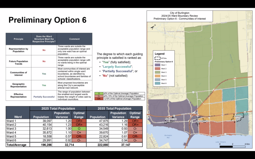
Option six prioritizes communities of interest, which were touched on earlier in the webinar when talking about the guiding principles that go into designing wards.
“Efforts should be made to avoid splitting neighbourhoods or communities of interest into different wards, considering community history, minority representation, and geography when generating ward boundary options,” read the slide in the presentation.
“We’ve done that [priortizing communities of interest] by adopting the school boundaries,” Spicer said. “And there is some logic behind this, given that school boundaries help to identify community connections and interaction patterns. Communities revolve around schools and they’re how families connect.”
This approach leads to more linear boundaries around Wards 1 and 2 but does sacrifice population parity, although these numbers would improve by 2035.
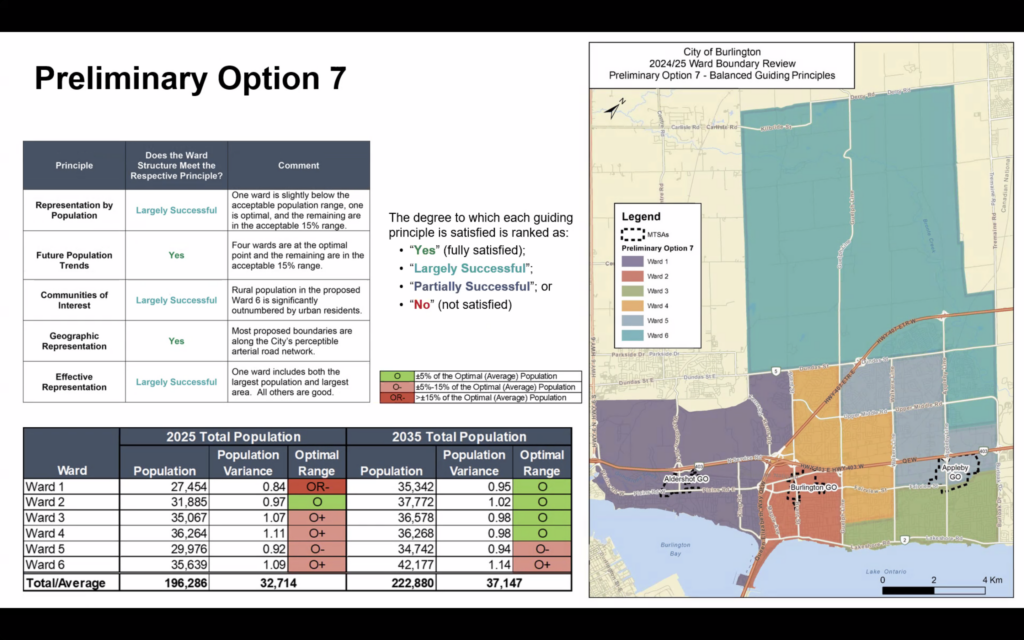
The final preliminary option attempts to balance all of the guiding principles.
“What you see here is a single rural ward and three lakefront wards with Ward 1, 2 and 3 riding along the lake and Ward 6 extending below the 407, Dundas Street, and the northern border of the city of Burlington,” Spicer said.
“This option provides for pretty good population parity both now and in the future,” Spicer continued. “The one exception is Ward 1, which would currently be outside the optimal range but, over time, does actually move nicely into population parity.”
Williams wrapped up the presentation by explaining that there is no one solution to all of the issues with the current ward structure and that residents are encouraged to give feedback to the consultants and the city about the aspects of each option that they like.
Williams also said that the options will most likely be whittled down to two, which will then be presented to the city in the spring. Council will make a final decision in the same season.
Maps containing all seven preliminary options can be found on the Get Involved Burlington website.
Williams encouraged residents to fill out the survey on the same website, where they can provide feedback regarding the proposed changes.
The survey and maps can be found by clicking here.